

Most Common Drone Questions from Survey Conferences
POB GUEST COLUMN - UAVS
by: logan campbell
Survey conferences from all over the country tend to cluster in the winter months. So, Aerotas bundles up and heads out into the cold to share lessons learned from processing thousands of drone survey projects. While the number of surveyors who use drones continues to grow, there are still a handful of questions that keep cropping up at almost every survey conference. In this article, we will answer the most common questions about drone surveying from this year’s conference season.
What type of data can I get with a drone?
Many people think that photos and videos are the only useful things that can come out of a drone program, but that isn’t true! Drone technology today is capable of getting enormous amounts of topographic and planimetric data using off-the-shelf drone hardware. Anyone who is only getting pictures and videos out of their drone is not utilizing the technology to its fullest extent.

The final survey should look the same whether it was made conventionally or with a drone.
I need high accuracy. How can I use a drone at all?
One of the significant criticisms of drone surveying is that they aren’t accurate enough for very high accuracy points, and this is true! Even the best drones are not going to be as accurate as a good, well-operated total station. The drone is your broad brush and should be viewed as just another tool in the truck. A drone is not a magic bullet, nor is it a stand-alone data collection device. The surveyor and their years of experience and technical expertise determine the right tool for the job. Preferably, the drone is a part of a mixed workflow. Use your highest accuracy tools for the shots that matter most, and devote your time and attention to shots where accuracy is paramount (e.g., building corners and ADA ramps). Then, use the drone for everything else (e.g., parking striping). There are many shots where 0.1’ error is perfectly OK, like rough topo or parking inventory surveys. A drone is a great tool for jobs where 0.1’ accuracy is good enough, but it is not going to defeat a total station in terms of accuracy anytime soon.
I’ve heard if you fly lower, you get better photos and higher accuracy. Is this true?
Not always! While it is true that flying lower will get you images with a higher resolution, that is only a portion of what determines accuracy. The quantity and distribution of ground control points is a much more significant factor in determining accuracy than flight altitude and photo resolution. In fact, in many cases, you can get better accuracy by flying higher just because there is less flexibility in the resulting photogrammetry model.
So what is the best altitude to fly at?
Goldilocks would tell you that 200' above ground level (AGL) is just right, but every project is different. In general, you should probably be flying higher. Error compounds and ultimate accuracy comes from the combination of hundreds of factors, but two of the most significant are flight altitude and the number of ground control points. In general, the higher you fly, the fewer ground control points you need. When you fly very low, you have to set a lot more ground control points to get decent accuracy. If you fly low without enough ground control, then your final project accuracy drops off sharply and winds up being much worse than it would have been at a higher altitude. Below is a rough table that we put together showing some of these tradeoffs.

Accuracy expectations for project planning

Accuracy spec determines ground control
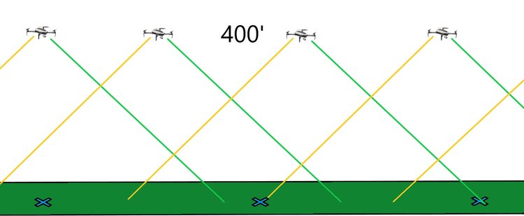

What is the appropriate overlap?
Our recommended overlap is 75% front-lap and 75% side-lap for almost every project, with a single set of back and forth flight lines (boustrophedonic pattern), and the camera pointing straight down (nadir) on all photos. These recommendations are in contrast to more popular suggestions of higher overlap, multiple cross-hatch flight patterns, and off-nadir or oblique imagery. At Aerotas, we have done significant testing on these different types of flight patterns and found almost no improvement in survey accuracy for the vast majority of projects. Instead, it causes an increase in field time, and a massive increase in data processing time, with no measurable benefit in accuracy. There are a few exceptions to this, such as highly repetitive land, like crops and dense vegetation, but for the vast majority of projects, additional overlap provides little to no benefit.

I was told that more data is always better. Now you are saying I should fly higher and with lower overlap?
Yes, and this is because there IS such a thing as too much data! Proper mission planning certainly helps to manage processing time. Adding more data means that a project will take more time in the field, take more time to process, use more data on computers and tax networks, and will be more challenging to manage in the various software programs utilized in the data processing workflow. We live in a world where human resources, software, and time all cost money, and more data takes more of all of these things. So if your drone program doesn’t have a budget or any project deadlines, then, by all means, collect more data. However, if you want your drone program to take up less time and to cost less money, then use as little data as possible to get the results you need. The surveyors that we work with are not running a research project; they are running a business and need the drone to save them time and money so that they can be more profitable.
What are the best settings for processing photogrammetry?
Unfortunately, there is no magic bullet when it comes to photogrammetry settings. People often look to tech companies and expensive software to automate everything, but photogrammetry is one of those technologies where, to get survey-grade accuracy, there is no one-size-fits-all package of photogrammetry settings. There is a reason photogrammetry is a Ph.D. level science. Furthermore, just because everything is green doesn’t mean your data is good. Instead, having a robust workflow of checking for errors throughout a project’s processing is the best way to get reliable and repeatable accuracy. Ultimately, the accuracy and quality of your photogrammetry outputs should be measured independently with checkpoints that were NOT used in the photogrammetry process, and those checkpoints should be evenly distributed throughout the project. Adjusting photogrammetry settings differently on different projects is necessary because project sites are themselves different. It is generally most reliable when photogrammetry is performed by someone certified in photogrammetry. To learn more about photogrammetry certification, we recommend checking out ASPRS (www.asprs.org).
I have the Phantom 4 RTK, do I still need to do any surveying on the ground?
Airborne RTK is a wonderful tool and has become much more mainstream ever since the introduction of the DJI Phantom 4 RTK, which has a dual-band GNSS antenna built into the aircraft itself. However, while this is a great tool that has delivered excellent results, it is not good enough to work reliably without any ground surveying. At the very least, every project flown with an RTK or PPK enabled aircraft should have a handful of checkpoints measured with ground-based surveying equipment. The checkpoints will allow you to verify that your RTK/PPK system is working as intended, calculate the exact amount of error in the project, and expose any processing blunders or mistakes that may have been made as part of the workflow. Because this is such a new technology, there are hundreds of possible errors in the workflow that often go unnoticed. Not having any checkpoint data with airborne RTK isn’t reliable enough to be considered survey-grade.
Is this a good site to use my Drone on?
This can be a bit of a misleading question because what you really should be asking is, “What data do I need to collect on this site?”, also, “Is the drone the right tool for this job?” If you need imagery for existing survey work, or want to have a reliable record of site conditions, then a drone is an excellent tool for almost every job. If you need topographic data, then a drone is a great tool provided the project site isn’t completely covered in trees. Photogrammetry based drones can only map what they can see. So if, for example, you needed to map the floor of a forest, the drone wouldn't be the right tool for that job.
I have airports and controlled airspace near my projects. Is it legal to fly there?
Over 98% of the land in the United States does not require any authorization to fly a drone up to 400’ above ground level; however, there are still major portions of US cities that are in controlled airspace. Thankfully, over the past few years, the FAA has considerably loosened their airspace restrictions, while also making it much easier and faster to get one-off airspace authorizations for project sites near, or even on airports themselves. Of the 15,000 airports in the US, fewer than 900 are in controlled airspace that requires authorization. Moreover, of those, nearly 500 airports participate in the FAA’s LAANC program. LAANC is the Low Altitude Authorization and Notification Capability; it provides access to controlled airspace near airports through near real-time processing of airspace authorizations below approved altitudes in controlled airspace. Non-participating airports can still grant authorization through a manual filing if needed. So in almost all cases, the answer is “yes” it’s legal to fly there, and it is much easier to get approval than it was even one year ago.
What data still needs to be surveyed on the ground?
Even the best drone surveying technology still needs to be augmented by surveying on the ground. Whether it is for technical, legal, or verification reasons, a good drone survey will always be complemented by at least some ground-work. Here are the major categories that need to be surveyed on the ground:
- Ground Control Points (GCPs) tie every project into all of the rest of your fieldwork and is a critical component of drone surveying.
- Check Points are similar to GCPs but are used to verify the accuracy of each mission independently.
- High Accuracy Points are those where the drone is incapable of getting the accuracy required by the survey. Depending on the requirements of each project, this can include things like building corners, ADA compliant ramps, and monuments.
- Areas that can’t be seen from the air also need to be surveyed on the ground. Whether obscured by trees, building eaves, or underground utilities, the drone can’t map what it can’t see.
Some points are legally required to be shot on the ground. While every jurisdiction is slightly different, in almost every state, property boundaries are required to be surveyed on the ground. Check your local laws to know what legally must be performed on the ground in your state.
Is your drone program saving you TIME and MONEY?
This is the most critical question that you should be asking yourself when using a drone for surveying. A well-managed drone program should be saving both time and money relative to ground-based surveying needs. If it isn’t saving time and money, then it isn't working. The good news is tools exist that can enable you to have a simple, reliable, accurate, and profitable drone surveying program; you just need to ask the right questions!