

The Mavic 3 Enterprise is DJI’s latest hardware release that is capable of performing survey grade mapping. It promises an advanced suite of capabilities and attachments to perform different tasks. Here, we are specifically going to focus on the RTK-enabled Mavic 3E, and how well it performs as a high-accuracy surveying and mapping tool. And now that we have had a few weeks to fly, test, and process data from this drone, we are able to provide a full in-depth review.
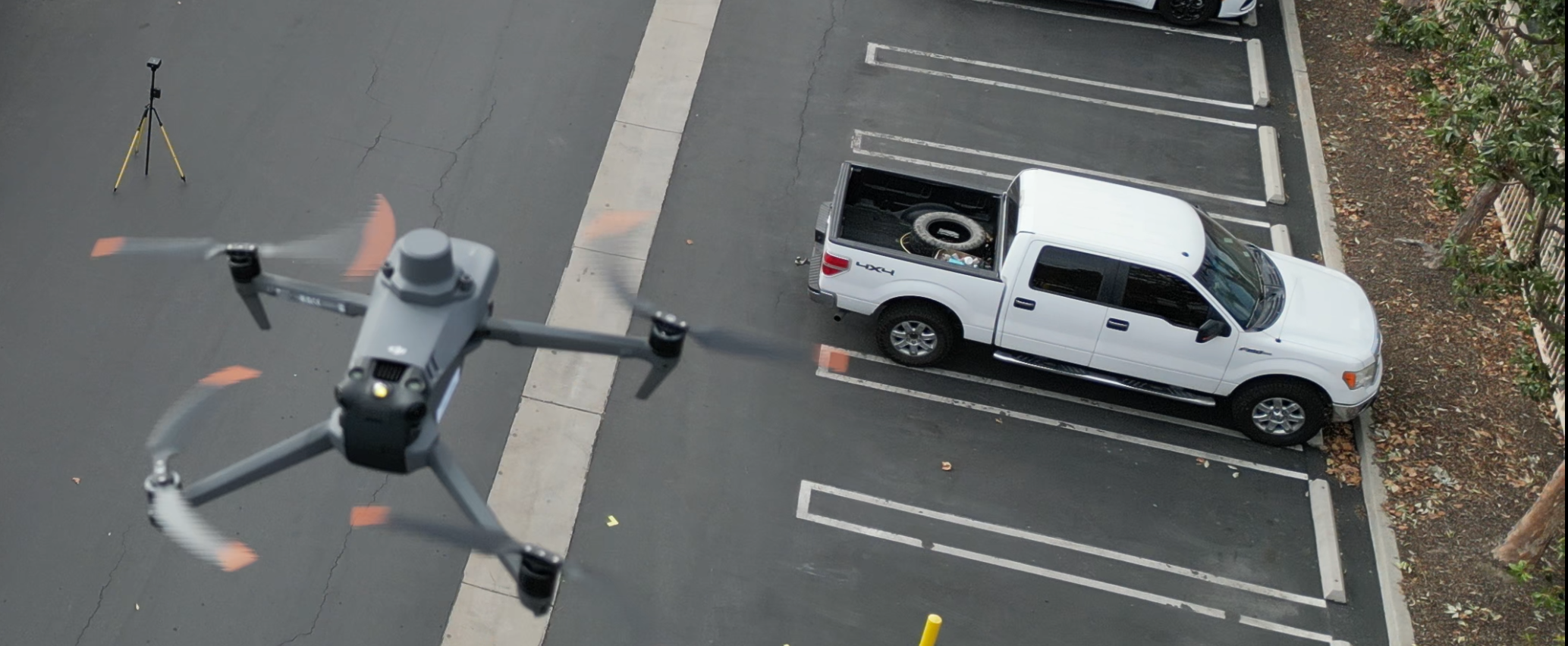
Mavic 3E in flight on one of our in-house test missions
When configured properly, the Mavic 3 Enterprise is an excellent surveying and mapping drone and will become the new standard for both performance and value in aerial mapping. Until now, the DJI Phantom 4 RTK has been the gold standard for drone surveying. The Mavic 3 Enterprise meets or exceeds the performance, capabilities, and value of the Phantom 4 RTK in nearly every way. The Mavic 3 Enterprise is not a revolutionary drone, and only provides minor improvements over the previous generation of drones, however it is a worthy successor to the phantom 4 RTK. We expect that the Mavic 3 Enterprise will become the workhorse drone for surveying and mapping applications for the next few years.
Review Methodology
Before we get into the actual details about the hardware, workflow, and data from the Mavic 3E RTK, it is important to understand our review methodology. We believe that a good drone is about much more than just the hardware. Instead, we look at the drone based on how well it will fit into a real-world workflow. The primary factors that we look at are:
Ease & Reliability of Use
Accuracy of the Final Data
Total Cost of Ownership: including the cost of equipment, operation, and data processing
This means that raw technical specifications, while important, are far less meaningful to us if they don’t reliably produce high-quality final accuracy. Likewise, the quality of the equipment doesn’t mean that much if it requires months of specialized training to use it properly. We will discuss all of these considerations throughout this review.
One last caveat is that this review is intended solely for producing survey-quality maps and measurements. If you are looking for how this drone can apply to other industries like public safety or agriculture, then you might be in the wrong place. But if you want to know how this drone works for surveying and mapping, then read on.
Hardware Review
The first thing we have to address with the “Mavic 3 Enterprise 3E with the RTK module” is the incredibly confusing name. The “Mavic 3 Enterprise” is the name of a group of drones, and the “Mavic 3E” is the version with the survey-capable camera. The “Mavic 3T” (Thermal) will not work for survey quality mapping. Likewise, you actually will need to add the “RTK Module” to the base “Mavic 3E” in order to get the results we are talking about.
Mavic 3 Enterprise 3E - for surveying as long as you use the RTK module

Mavic 3 Enterprise 3T - Not for surveying
Also, don’t be confused by the standard “Mavic 3”, or the “Mini 3”, or the “Mini 3 Pro” as those are entirely different drones that you can’t do proper mapping with. We think this naming convention is absolutely ridiculous and will lead to a lot of uninformed buyers purchasing the wrong drones. We definitely recommend buying from a trusted supplier just to make sure you don’t buy the wrong one. And yes, we sell them here at Aerotas! Feel free to contact us if you’re interested in purchasing one.
Onto the drone itself. Overall, the hardware quality is very good, and in line with most of DJI’s other enterprise grade hardware. It feels much sturdier than most of the drones in the previous consumer Mavic series, or the Phantom series of drones. The batteries latch in very securely, with little risk of coming loose or not being fully secured. The SD card is somewhat difficult to access, hidden under a small flap on the back of the drone, and is hard to extract without fingernails. This can be a bit frustrating as you will want to access the SD card after every mission, and it is effectively impossible to do with gloves. The folding legs feel secure and don’t seem like they would ever become a failure point, even after years of use.

The controller that comes with the drone is the “DJI RC Pro.” This controller will be familiar to anyone who has worked with an M300, and is a substantial upgrade over the integrated controller on the Phantom 4 RTK. The 5.5” screen is bright and easy to use outdoors. It runs software on a version of Android, and is much more responsive than previous generations of controllers. The software that it runs is DJI Pilot 2, which is plenty good enough for all surveying and mapping needs, including terrain aware flights, without additional 3rd party software.
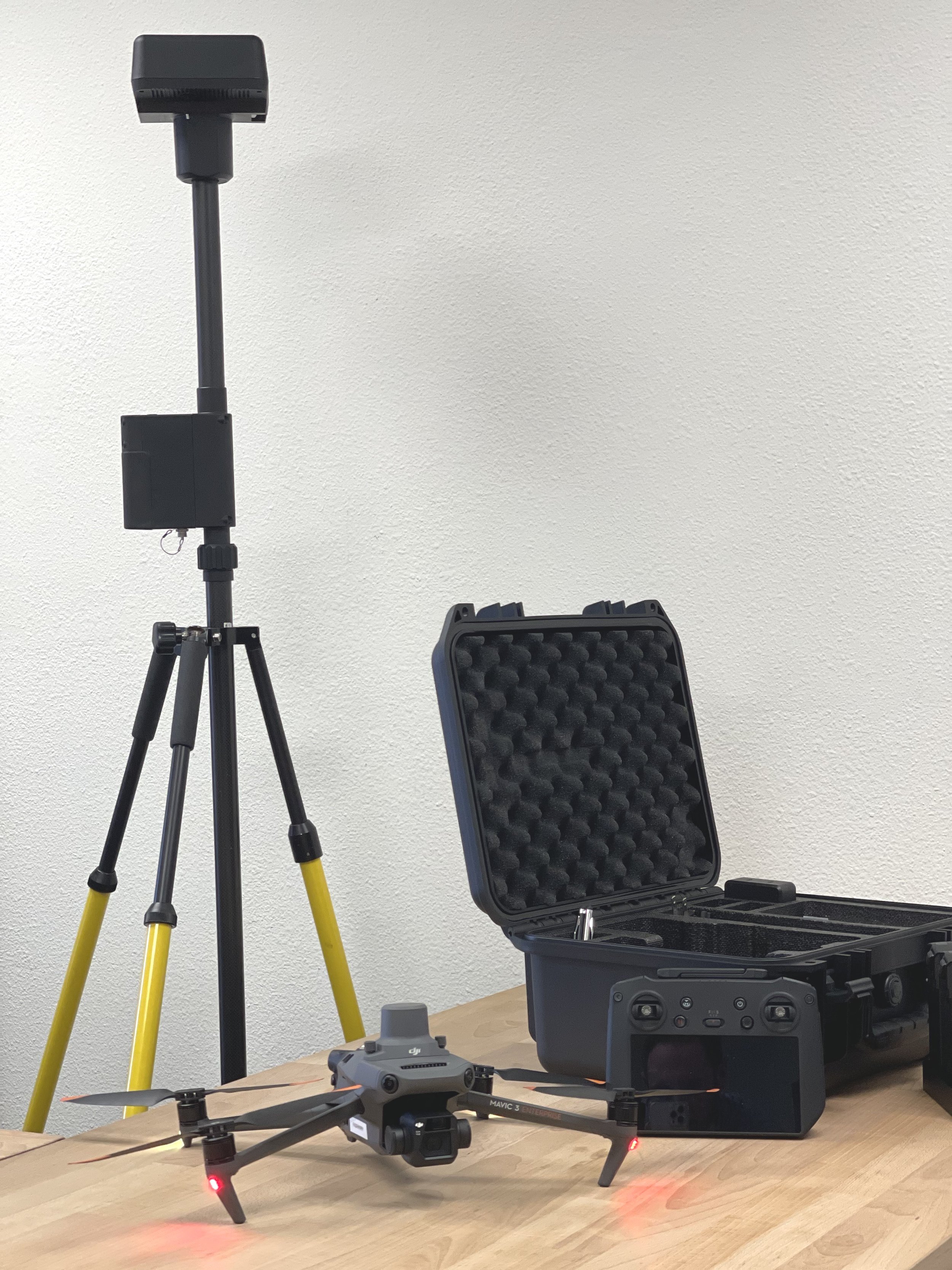
As previously mentioned, the Mavic 3 Enterprise has folding legs to make the drone much smaller and easy to transport, and this size is a major benefit. In fact, most of what you need to fly can be fit into a hard case the size of a briefcase. While this takes up much less space than the Phantom 4 RTK and its associated equipment, it actually doesn’t make a huge overall difference over prior generations. That is because, in order to work at its best, the Mavic 3 Enterprise still needs to be paired with a GPS base station, which will take up much more room than the drone itself.

A field-ready M3E, all in a compact case (minus the D-RTK-2)
For this review, we used the DJI D-RTK-2 base station, which is identical to the base stations that DJI has been selling for years. As with previous RTK-enabled drones, the Mavic 3 Enterprise is capable of working with multiple different GNSS post-processing workflows, however the integration with the DJI base station is by far the easiest and most reliable, and that is no different here. In fact, while testing this workflow, we were able to swap a single D-RTK-2 base station between the Mavic 3 Enterprise, a Phantom 4 RTK, and an M300 without any issue.

As mentioned: the M3E Camera
The primary camera on the Mavic 3E is a 4/3” CMOS sensor with 20 megapixels, a mechanical global shutter, and an 84° field of view. This is nearly identical to the Phantom 4 RTK, which had the same specifications on a 1” image sensor. This means that the Mavic 3 should have slightly improved performance in low light scenarios. Overall, these specifications are ideal for mapping but represent only minor improvements over prior generations.
It is worth noting that the Mavic 3 Enterprise series does NOT offer any lidar modules, nor is it likely to ever offer any quality lidar attachments to this drone. The drone simply cannot carry the weight and power required to run a survey quality lidar sensor. If you need lidar, look to the DJI M300 drone with the L1 sensor.
The drone itself also offers highly comparable technical specifications to the Phantom 4 RTK, with a handful of minor improvements. Rated wind resistance has increased from 23 mph to 27 mph, minimum ambient temperature is lower at 14°F compared to 32°F on the Phantom 4 RTK, and maximum speed is up to 47 mph from 36 mph. While these are welcome improvements, they have very little impact on the overall quality and usefulness of the drone.
When it comes to flight times, DJI is notorious for egregiously overstating the flight time of its drones, and that is no different in this case. The Mavic 3 Enterprise is rated for 45 minutes of flight time. However, in real-world operation, it can fly for at most 30 minutes before needing to come home, and that is allowing it to run down below 15% charge. 30 minutes of real-world flight time per battery is still very good, but a far cry from the totally unrealistic 45 minutes that is reported.

The RTK specifications of the Mavic 3 Enterprise are very comparable to previous generations. The rated RTK accuracy is 1.0cm horizontal, and 1.5cm vertical, which is identical to the Phantom 4 RTK.
Overall, the hardware of the Mavic 3 Enterprise is excellent, and exactly what we would hope for from this drone. There are minor improvements over the Phantom 4 RTK, but nothing game changing. Overall, it is a well built and very functional piece of mapping hardware.
Field Workflow
The field workflow for the Mavic 3 Enterprise will be extremely familiar to anyone who has flown a DJI drone in the past few years. The mission can be planned in the office using the built-in screen and built-in software on the remote controller. Planning is much easier than with the Phantom 4 RTK thanks to the bigger screen and faster chip powering the “RC Pro”. Also, Planning a flight with terrain awareness is much easier that in previous generations which is a welcome upgrade.
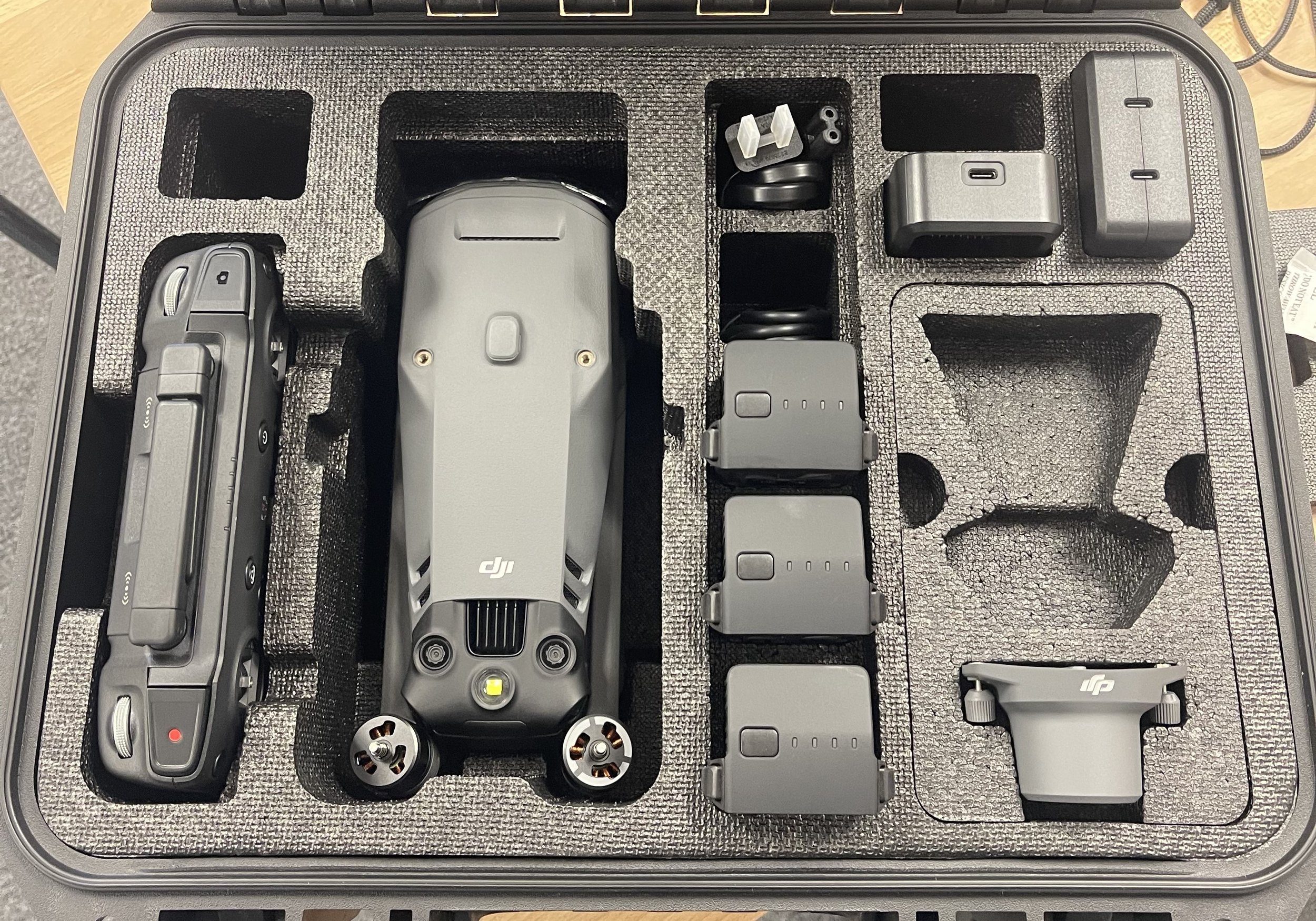
All you need to collect Survey-Grade data with the M3E is seen here.
As with other RTK capable DJI drones, the Mavic 3 Enterprise is capable of a broad suite of GNSS processing workflows. This ranges from network corrected RTK, to using the DJI branded D-RTK-2 base station, to 3rd party base stations streamed over NTRIP. Which of these workflows to use is beyond the scope of this article, other than to say that the Mavic 3 Enterprise can be used for all of them. As with the Phantom 4 RTK, our recommended workflow is using the D-RTK-2 local base station due to the precision granted by short baseline distances, and the simplicity and reliability of the connection between the drone and the base station. However, we highly recommend reading our full article on which workflow might be best for you.
Once the mission is planned and the drone and RTK system set up, flying the drone is incredibly simple. The drone flies fully autonomously, completes its mission, and then returns home. If the drone runs low on battery, it comes home earlier for a battery swap before continuing the mission. It is simple, relatively straightforward, and easy to use.

As usual, DJI remains the overwhelming market leader in a simple field workflow. There is no complex system troubleshooting required, and it does not require much training to learn how to operate the drone system properly. We don’t have much more to say about the field workflow, other than this is where other drone manufacturers really ought to take note. DJI absolutely blows away the competition when it comes to simplicity and reliability of their field workflow, and that is a major part of why we continue to rate DJI drones so highly.
Data Quality
Quality hardware and a good field workflow is great, but isn’t worth very much if the resulting data isn’t any good. Reviewing the actual data quality is critical before we can recommend a drone for surveying and mapping.
In order to test the quality of the data, we ran a total of 4 flights.
Flight 1 - Mavic 3E at 200’ AGL
Flight 2 - Mavic 3E at 400’ AGL
Flight 3 - Phantom 4 RTK at 200’ AGL
Flight 4 - Phantom 4 RTK at 400’ AGL
All 4 of these flights were flown with the DJI D-RTK-2 set up over a point that was not previously measured in order to mimic a realistic field workflow, along with 75% front and 75% side overlap, over a 12 acre office complex test site, comprised of hardscape, buildings, trees, and lightly vegetated areas.
To measure accuracy, 19 points were marked on the ground using survey quality dual-band GNSS equipment with an estimated horizontal precision of 8mm (0.026’) and an estimated vertical precision of 15mm (0.049’). Each data set was processed two times, once with no points used as control and all points used as checkshots for measurement, and a second time with 3 points used as control with the remaining 16 points used as checkshots.

In all cases, the comparative differences between the Mavic 3 Enterprise and the Phantom 4 RTK were close enough to be within the margin of error. Further, if measured according to the ASPRS Positional Accuracy Standards, then all flights are of high enough quality to exceed the highest possible accuracy class allowable given the precision of the ground-based equipment used to measure the checkshots.
That said, it is interesting to note that the Phantom 4 RTK had a better standard deviation of error when no ground control points were used at all. This could indicate that the Mavic 3 Enterprise’s camera is slightly more susceptible to small variations in camera calibration than the Phantom 4 RTK. However, as the maximum difference in results between the two systems is only 0.03’, it is entirely possible that this is due purely to statistical noise, and not any meaningful difference between the two systems.
The overall conclusion of the test is that the data quality between the Mavic 3 Enterprise and the Phantom 4 RTK is statistically indistinguishable. Based on data quality alone, the Mavic 3 Enterprise produces data that is of identical quality to the prior generation. This alone would launch the Mavic 3 Enterprise above all but the most expensive and specialized surveying drones available. But combined with the aircraft’s incredibly simple workflow and miniscule size, the Mavic 3 Enterprise is sure to become a very popular drone in the surveying and engineering communities.
Data Processing
Processing and analyzing photogrammetry data is difficult. Beyond that, actually extracting useful data from the 3D model can be incredibly time consuming. Thankfully, our speciality here at Aerotas is doing drone data processing for land surveyors and civil engineers throughout the United States. If you are interested in starting a drone program, or if you are already processing drone data and are looking for ways to save time and money in your drone program, please reach out to us using the link below. It is through support from customers like you that we are able to produce content like this going forward.
Price & Value
At Aerotas we believe that a good drone program must not only gather good data, but it has to do so profitably. And to do that, the drone has to produce good value for the money. The Mavic 3 Enterprise proves to be a fairly good value proposition overall.
The Mavic 3 Enterprise drone by itself costs $3,810, which would be a great deal. However, do not be fooled by this low list price. This version of the drone, with nothing else attached, is no more useful than a Phantom 4 Pro that cost $1,500 a few years ago.
In order to get all the equipment you actually need for survey quality mapping, you would also need the RTK module ($709) and the battery kit ($659). You also will need some form of GPS base station solution, with the one that we recommend being the DJI D-RTK-2 base station ($3600) along with its Tripod ($250) and case ($150).
Pictured above are 3 major components of a useful Mavic 3E surveying kit - the Mavic 3E, the RTK Module, and the Battery Kit
Lastly, you always should figure in the minor accessories and intangibles to a business grade drone program. Anyone that has worked with DJI on their hardware support and service knows that trying to call someone to troubleshoot a drone in the field is basically impossible, and working to get a damaged or nonfunctional drone replaced can take a huge amount of work. So we always recommend working with a vendor that provides a support and service package along with all of the hard equipment.
When you add all of this up, you should expect to pay around $12,000-$13,000 for a fully featured Mavic 3 Enterprise RTK setup. And yes, we at Aerotas do sell the Mavic 3 Enterprise RTK, so if you’d like to learn more about ordering one, please let us know using the link below.
Conclusion

The Mavic 3 Enterprise RTK is the new gold standard for drone surveying, and one that we would recommend to any land surveyor looking to work in photogrammetry. While it is better than or equal to the Phantom 4 RTK in nearly every category, the improvements aren’t that significant, so if you are operating a Phantom 4 RTK currently, it probably is not worth the upgrade. However, if you are running an older variant of the Mavic series, or a non-RTK version of the Phantom, or any of the Autel or Yuneec suite of drones, then this is a great upgrade. And while the Mavic 3 Enterprise RTK cannot compete with the raw power of the M300 with its L1 or P1 sensor, its small size, ease of use, and much lower cost will make it the preferred choice for the majority of circumstances.
If you have any questions, comments, concerns, or would like to know more about if a drone program is right for you, please feel free to contact us at the link below.