
Finding A Place for Drones in Surveying
POB: December 2019
The steady rise of unmanned aerial vehicles still leaves surveyors and photogrammetrists with questions.
BY LINDA DUFFY
>>Read the full article at www.pobonline.com, or check out the December 2019 POB Digital Edition
““To get good results with less expensive software programs and UAV, it really helps to have a certified photogrammetrist on staff,” says Sherby. “It’s not as simple as just collecting data and pushing a button. Someone needs to thoroughly understand the process to get the required results. That’s why we have a licensed surveyor and an ASPRS Certified Photogrammetrist involved in each project.””
The use of drones — or unmanned aerial vehicles (UAV) — is commonplace in today’s consumer and commercial worlds, and the range of product and software options continues to expand. The rapid development of the drone industry is driving many survey businesses to explore how to leverage these tools within their existing workflows to improve productivity and lower costs.
Early on, difficulties with processing drone images suggested they could not meet the high mapping standards of surveyors; however, advances in aerial photogrammetry software allow drone data, even when collected with consumer-grade UAV platforms, to be used successfully for many applications.
Every Project is Different
Drones provide value as an additional “tool in the toolbox” rather than as a total replacement for terrestrial and manned aerial platforms. They offer advantages in certain situations, and there are numerous mapping activities that can be accomplished with drones to improve efficiency, performance, and profitability.
Cost is a key consideration in any mapping project. Collecting and processing the necessary data efficiently, with limited revisits and rework, is the goal. Selecting the best tool for the job should be based on the size of the area of interest, the weather, the terrain, and the specifications of the deliverables. Sometimes a manned aircraft equipped with a LiDAR scanner will be the obvious choice, such as for a statewide topographic project or a heavily forested area. But what about a three-acre construction site that requires weekly updates? A $1,500 drone and camera are probably going to satisfy the requirements at a lower cost and with a faster turnaround.
Specifications may vary for different parts of projects, so careful planning results in the best technology being used to meet each requirement. For example, if 90 percent of a two-mile roadway survey has a lower accuracy requirement than the ADA-compliant ramps at the intersections, 90 percent of the area can be flown with a UAV, while a total station is used to capture the high-accuracy ADA-compliant ramps. This combined approach saves time in the field and leverages the strengths of each device.

Using AutoCAD Civil 3D, ASPRS Certified photogrammetrists at Aerotas draft and integrate all linework from 3D models.
There is a wide range of drones and processing software on the market. Very high-end drones are powerful enough to carry multiple sensors on longer flights and include direct georeferencing capabilities that reduce the number of ground control points (GCPs) needed.
Higher priced software may process data faster, which translates into increased productivity. However, surveyors who are typically handling smaller jobs, say .5 – 250 acres, can find less expensive platforms and software that also meet their needs and allow them to get started offering drone services without a large financial commitment.
“Initially there was a lot of skepticism that UAV photogrammetry can achieve the same level of accuracy as LiDAR from an aircraft or on the ground,” says Jon Ellinger, remote sensing manager, S&F Land Services. “I have been flying a Phantom 4 Pro for years and have found it to be very effective, especially in hard-to-reach terrain. Processing the data with Pix4D and performing 3D feature extraction with TopoDOT for very large projects allows us to deliver traditional CAD design work as well as orthomosaics and 3D models that meet our clients’ project requirements.”
Early Drone Adopters
Some early adopters in the surveying profession performed their own analysis to compare the results of UAV photogrammetry data with other common-practice surveying methods such as total stations and GNSS. Several years ago, customers started asking S&F Land Services in Portland, Oregon, about drone data and whether UAVs were a good alternative for their projects.
“When an unknown technology is introduced, we have to prove its accuracy because our reputation as surveyors is on the line,” says Christopher Sherby, PLS and owner, S&F Land Services. “In mid-2017 we started testing UAV data against our conventional methods, to identify types of projects where it works and where it doesn’t. Today we still collect several independent observations on every UAV flight using conventional methods to ensure the information is within tolerances. QA/QC is absolutely necessary no matter what technology we use.”
Although collecting LiDAR data with UAV is now possible with compact lightweight sensors, a camera is typically less expensive. With the right software and expertise, photogrammetry using images rather than LiDAR produces maps appropriate for numerous applications.
“To get good results with less expensive software programs and UAV, it really helps to have a certified photogrammetrist on staff,” says Sherby. “It’s not as simple as just collecting data and pushing a button. Someone needs to thoroughly understand the process to get the required results. That’s why we have a licensed surveyor and an ASPRS Certified Photogrammetrist involved in each project.”

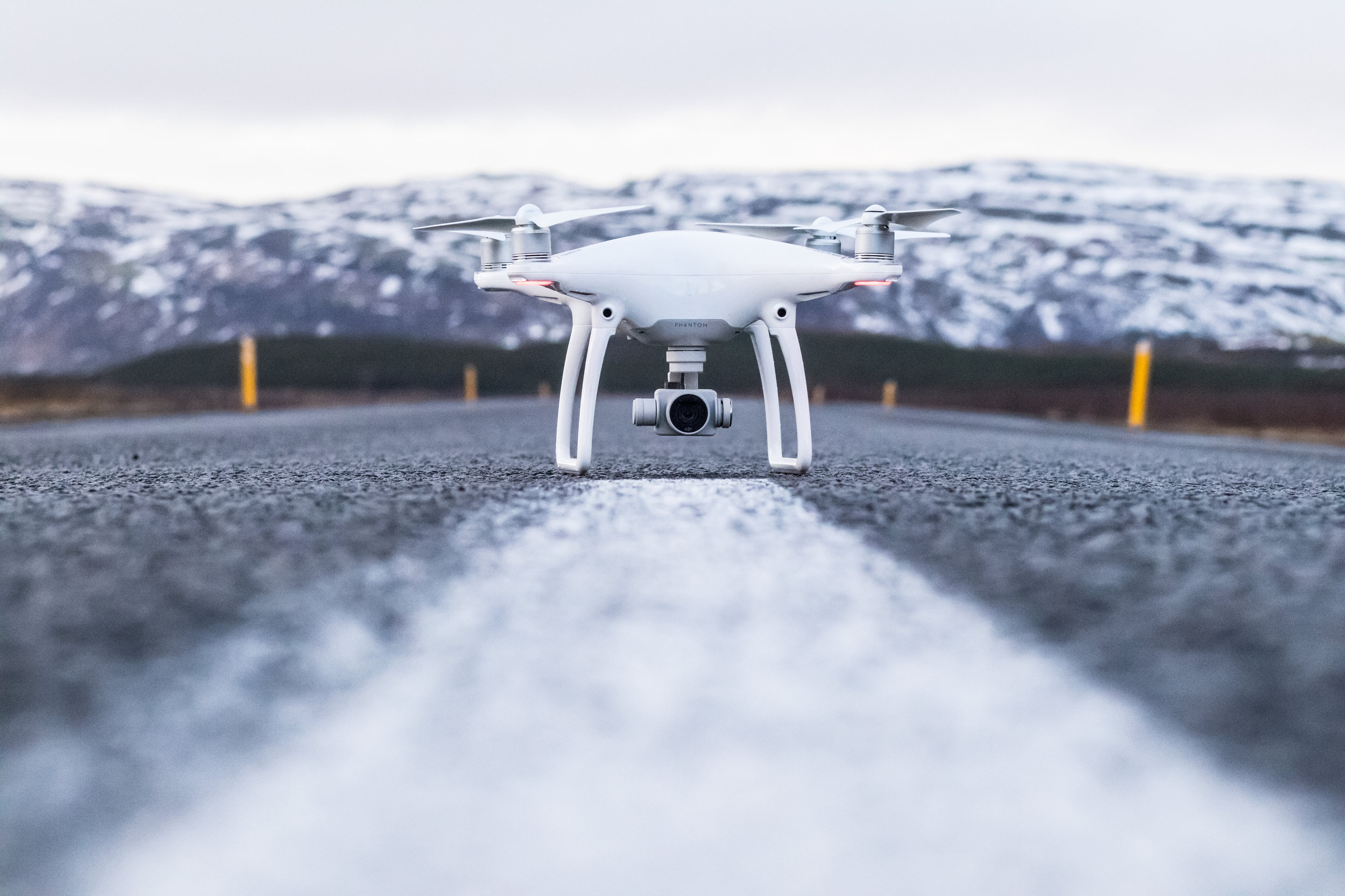
The compact Phantom 4 RTK drone is easily deployed in the field.
Contract Processing
Contracting for data processing is an option for surveyors who do not have the expertise to perform UAV photogrammetry in-house or don’t want to invest in the necessary computing hardware and software. Starting with some basic guidelines during data collection, such as 75 percent overlap, visible ground control points (GCPs), and nadir imaging only, a firm can upload data to a processing specialist and receive full-resolution orthomosaics, digital surface models (DSM) and point clouds, as well as 1’ contours, breaklines and other linework.
Aerotas, based in Costa Mesa, Calif., started its business offering custom photogrammetry, but soon realized scaling its production capabilities was the best way to meet the service goals of higher quality deliverables in less time for less money. Today the staff of ASPRS-Certified Photogrammetrists processes drone data for licensed surveyors and engineers and delivers all photogrammetric products and drafted linework (e.g., points, polylines, TIN).
The flight operations team at Aerotas consults with customers prior to data collection to establish the flight specifications needed for successful processing, including the number of GCPs, flight altitude, flight overlap, etc. Aerotas uses a threshold of approximately 0.1’ (3 cm) acceptable error on a project. If larger errors are detected the customer is notified.
“By establishing a standard workflow, we can produce reliable repeatable accuracy,” says Logan Campbell, CEO, Aerotas. “We perform 90 percent of our photogrammetry work using Pix4D software, followed by drafting and integrating all the linework from the 3D model using AutoCAD Civil 3D. These software products deliver high quality data without requiring a huge amount of time. After all, the goal of this technology is to save time and money. If you spend 100 hours wrestling with the software, it doesn’t save you time compared to just doing the work in the field.”

A Pix4D rayCloud creates a visualization that integrates the 3D representation of the project area and the original images.
Continuing to Improve
To address some of the lingering doubts that surveyors might have about using drones, software manufacturers are trying to work with the industry to make their products more useful. Pix4D recently announced the development of a new product called Pix4Dsurvey. It is specifically designed to handle large merged datasets and simplify point cloud feature extraction, while maintaining accuracy and effectively working with various coordinate systems.
“Software is much more comprehensive than just a few years ago,” says Ellinger. “I am a Pix4D Ambassador, so I test beta products and communicate my findings to the developers. They are trying to add value for surveyors and meet the industry’s needs.”
Along with terrestrial and aerial technology, drones are another tool to be utilized to meet increasing demands for accurate information delivered quickly.
“I feel that drones are providing benefits to surveyors – it’s not something they’re being forced to accept,” says Campbell. “More options empower them to get better data and deliver extras to their customers at a lower cost.”
BY LINDA DUFFY
Originally posted at www.pobonline.com, and available in the December 2019 POB Digital Edition.