The DJI L3 Lidar System for Surveyors - A Technical Deep Dive

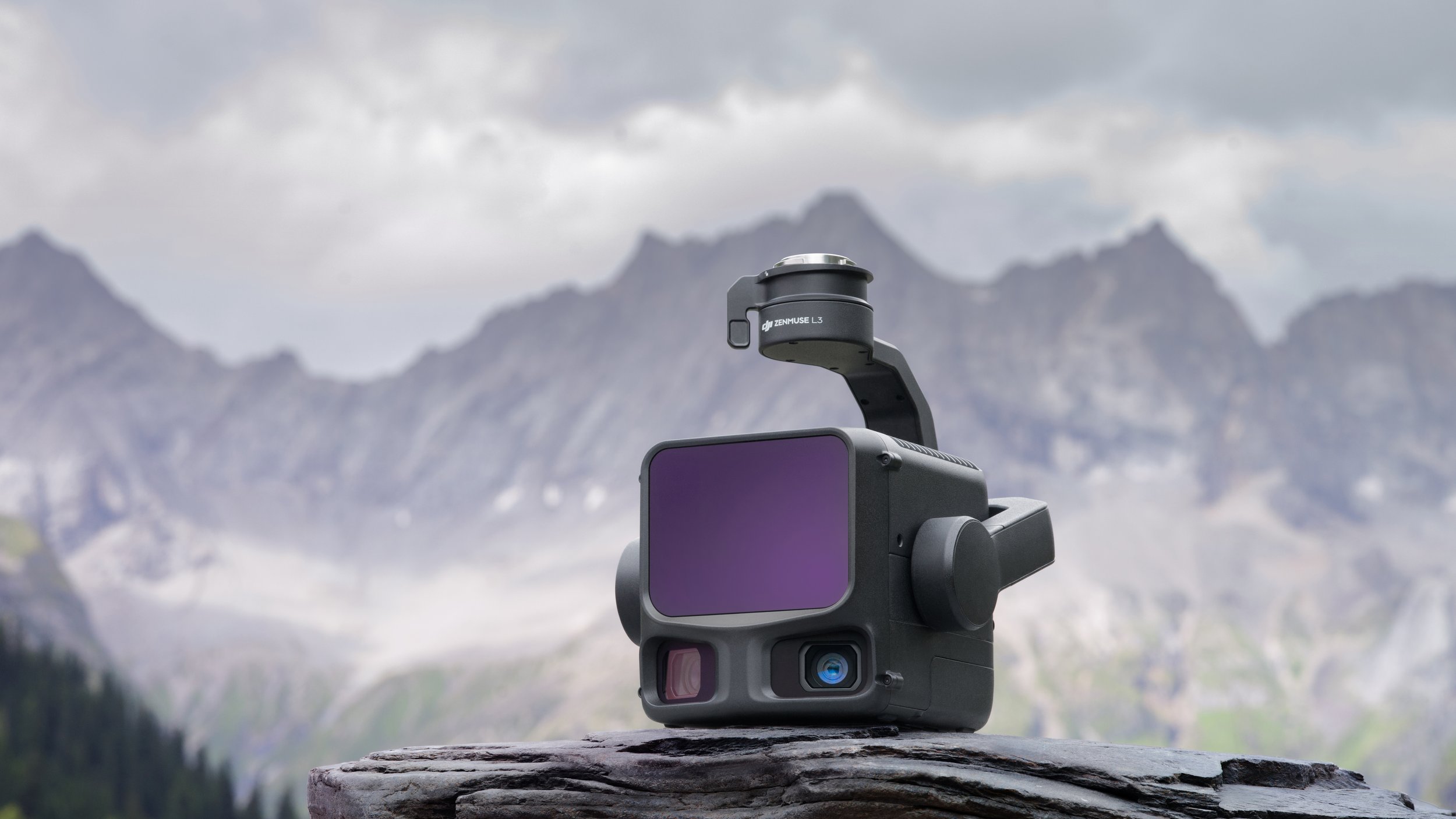
On November 4th, 2025, DJI announced the latest upgrade in their aerial lidar sensors, the Zenmuse L3. This is the latest upgrade in their lidar sensor line, replacing the previous L2 sensor. The L3 doesn’t have a firm release date yet, but we do have all of the technical information available to run a full analysis of what it can do. It promises a number of impressive sounding specs, such as a 1535nm laser, and dual 100MP mapping cameras, but how will it actually perform in practice? As usual at Aerotas, we will be analyzing everything from the perspective of aerial land surveyors and civil engineers who are looking to do precision surveys with this equipment. So will it be a good sensor for surveyors? And should US surveyors even consider investing in a DJI product given all of the regulatory uncertainties in the world right now? Let’s dive into the details to find out.
Aerotas Webinar
We hosted a Webinar going through all the L3 specs in detail, while answering live questions from surveyors about what the L3 will look like. Check it out below:
Summary
The DJI L3 is, quite simply, the new standard in aerial surveying lidar systems. The technical specifications are on par with the best lidar sensors in the industry, with a significant improvement over the previous generation L2 sensor, and massively improved over the first generation L1. Combining this with DJI’s overwhelming market leadership in drones that are easy to use and reliable in the field, the L3 will unquestionably set a new standard for aerial lidar performance.
But where the L3 really blows the competition away is in price. While final pricing is not yet formally announced, we expect final real-world pricing to be between $15,000 and $20,000 for the L3 sensor, and a total system including the required M400 drone and supporting equipment will cost in the mid $40,000 range. A system of comparable performance from a company like Riegl would easily cost $200,000 or more, and require a staggering amount of training, system integration, and supplemental software.
DJI used to be known for good value sensors, while other lidar manufacturers claimed better performance, but at much higher prices. With the L3, DJI now brings ultra-premium technical specifications at a price point that no other manufacturers are even close to.
DJI L3 Technical Analysis
DJI has listed the full tech specs of the L3 on their website, and they are full of a lot of technical jargon mixed with marketing hype. In this section, we’ll go over all the key tech specs and explain what they mean for Land Surveyors and if they are actually important.
-
The 1535nm Laser allows for higher power output than the 905nm laser on the L2 and previous drones. They haven’t been used in the past because it is more expensive and difficult to manufacture. The 1535nm laser enables longer range mapping, which will allow surveyors to fly higher and cover more land than before.
-
This specification is heavy on the marketing. While the sensors may technically be 100MP each, they are still limited by the physics of their lenses and image sensor size. In practice, we expect this to function like two 25MP mapping cameras. To be clear, this will still be an excellent photogrammetry capable imaging system, but the “100MP” number overstates the improvement in the real world.
-
A 950m (~3,100 feet) laser range is spectacular. While the number is likely overstated and won’t be that good in the real world, what it does mean is that the L3 can fly at an altitude of 400’ above ground (the maximum flight altitude for most US flights) and still collect high quality data.
-
This number means very little for surveyors. 2 million points per second requires limiting other capabilities of the drone, would create enormous data files that are difficult to use, and provide no meaningful improvement in data quality. We expect most missions to be flown between 200k and 400k points/second.
-
We will be very interested to test this feature in real world conditions, particularly in challenging environments such as dense, low grasses. However, we expect most missions to fly with only 8 returns enabled. This is a great feature, but not a huge improvement in the real world when compared to the previous generation 5-return sensor, which is good enough in virtually all circumstances.
-
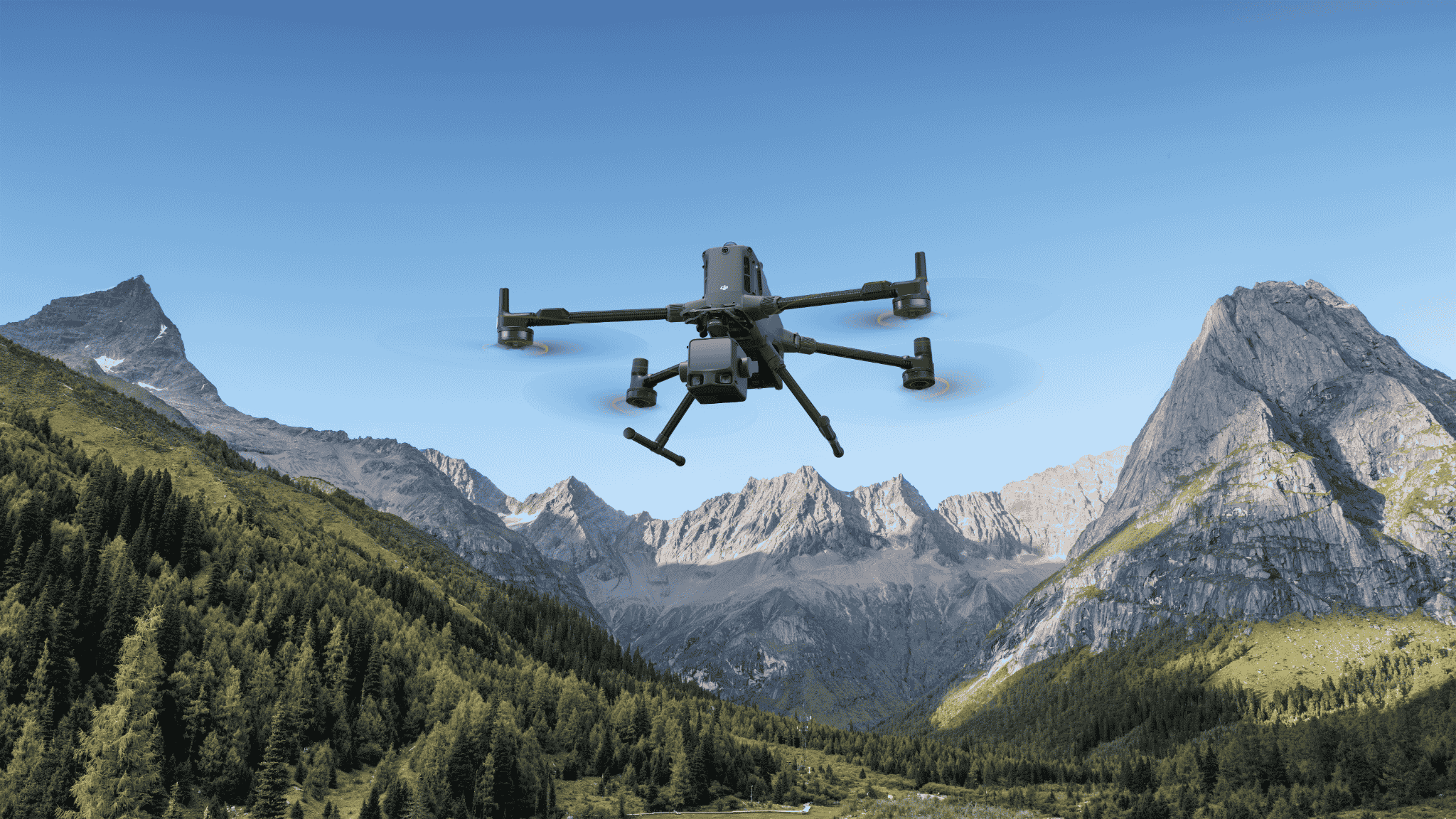
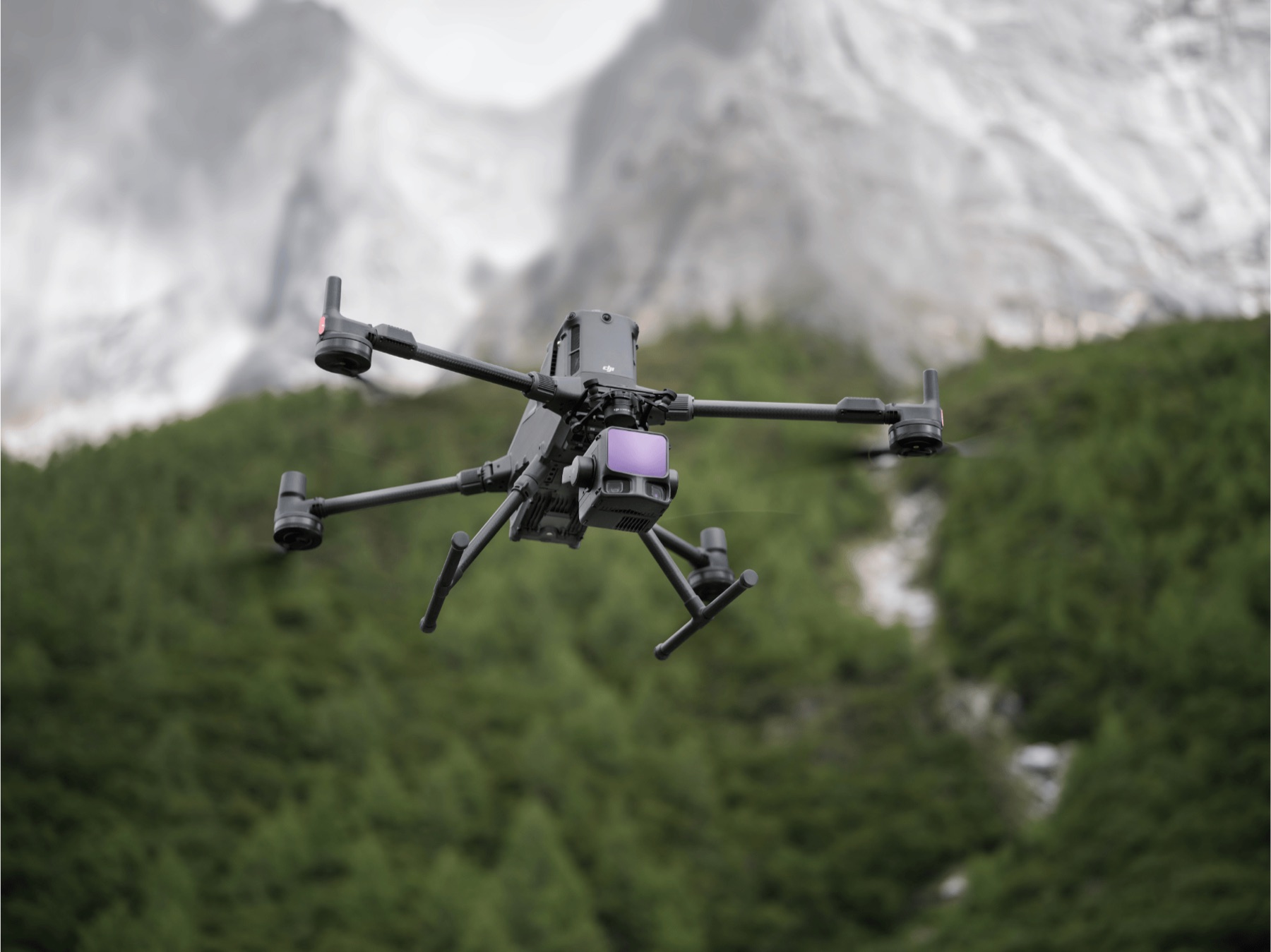
The L3 is larger and more power-hungry than previous DJI lidar sensors, and will only fly on the DJI M400. It cannot be attached to prior generation M300 or M350 aircraft, nor can it be adapted to fly on any non-DJI platform. This is surely disappointing news for those flying on an M300 or M350 who want to upgrade their sensor, but at least the newer M400 does bring improved flight times and better, bigger batteries.
-
This is quietly one of the more significant upgrades that the L3 brings over previous sensors. This is a much narrower laser beam footprint when it hits the ground, with a footprint of 3cm (0.1’) when flying at 100m (~300’) above ground. In practice, this means much better resolution of horizontal features, which should enable much more accurate mapping of things like curblines. This will be fantastic for developed areas with lots of hardscape.
-
Total system accuracy is where the rubber meets the road. It doesn’t matter if the laser is accurate to under a millimeter, what matters is the final accuracy of the map. 4cm vertical and 5cm horizontal is approaching the upper limit of accuracy you can expect from systems that significantly rely on GNSS for processing, and is on par with the best systems out there. With strong post-processing, we wouldn’t be surprised if final mapping accuracy according to ASPRS standards was even slightly better.
-
This is a moderate improvement over previous generations, allowing for higher scan angles and covering more ground per swath. It is another in a list of nice, but not game-changing improvements.
-
The dual-camera setup allows for each of the mapping cameras to be tilted outward, enabling a larger 107° field of view, while each individual camera only has an 84° field of view. This will better allow the system to process both photogrammetry and lidar simultaneously, which is Aerotas’ preferred workflow. In practice, this means that surveyors can cover slightly more acreage per flight without sacrificing data quality, which is always a welcome improvement.
Tech Specs In Practice
So what do all of these tech specs, when taken together, mean in the real world? The end result is that, when using the DJI L3, you can fly higher than ever before and cover much more ground per minute or per flight, all while getting better overall accuracy, better reliability in different environmental situations, and better 2d feature definition.
Basically, this system is better in virtually every way than any previous DJI sensor. The only slight downside is that it is a little bit bigger and heavier than previous generations, requiring a drone (the M400) that is a little bit bigger and heavier than its predecessors. But overall, it is a fantastic technology that will make every surveyor’s life easier.
The DJI L3 vs. Competitors
The DJI L3 is not the only aerial lidar system on the market. Many surveyors already have prior generation L1 or L2 sensors, or one of the myriad systems available from companies like GeoCue, Riegl, Yellowscan, Rock Robotic, and more. So how does the L3 compare to other systems on the market?
The DJI L3 vs. Previous DJI Lidar Sensors

Comparing the L3 to previous generation DJI sensors is easy. The L3 is better in virtually every aspect. A more powerful laser enables better range, better accuracy, and better coverage. The jump from the L2 to the L3 is more significant than we were expecting, enabled by the upgrade to a 1535nm laser. One of the most impressive parts of the L3 is that it is not materially more expensive than its predecessors, despite being far more powerful. When we first started learning about the L3, we were expecting it to be a much more expensive sensor that might even live alongside the L2 as a more budget friendly option. But since they are both priced in the $15,000-$20,000 range, it will rarely make sense for someone to buy a new L2 sensor when the L3 is an option.
If you are currently flying a DJI L1, then it is probably a good time to upgrade your system to the newest L3. If you are flying the previous generation L2, then things become a bit trickier. Very heavy users that often fly large sites should consider an upgrade to the L3, but if the L2 is serving your mapping purposes well, it probably isn’t necessary to upgrade right now.
The DJI L3 vs. Non-DJI Competitors
The L3 specs are on par with the highest end drone lidar systems available today.

The gold standard for non-DJI lidar systems is the Riegl VUX-1 UAV system. This system boasts a 1550nm laser with very impressive performance metrics. It then gets built into a payload by system integrators like GeoCue or Yellowscan that turn it into a complete payload. The end result is a system that has very comparable technical specifications to the DJI L3.
The catch is that these systems are hundreds of thousands of dollars more expensive than the L3. The L3 costs $15,000-$20,000. A Riegl VUX based system will cost 10x or more than the L3, with complete systems often costing in excess of $250,000. The DJI L3 matches these performance specifications at a tiny fraction of the price.
Cheaper non-DJI systems will still cost in the $50,000-$100,000 range, and will have dramatically inferior specifications, often relying on weaker 905nm lasers and lower quality cameras and IMUs.
Further, every DJI competitor is a complicated mix of different companies. It needs to involve a laser manufacturer with a systems integrator with a different company that builds the drone airframe, and they become a Frankenstein's monster of technological complexity. The data quality is often excellent, but these systems are incredibly difficult to use quickly, easily, or reliably.
Put quite simply, The DJI L3 is cheaper, better, and easier to use than any alternative available today. By a wide margin.
DJI and the US Regulatory Environment
There are a number of people who are concerned about buying a DJI drone right now, given that DJI is a Chinese company, and US-China geopolitical tensions are fairly high right now. Further, there is a great deal of chatter about a nebulous “DJI Ban” that could happen in the future. So where do we stand on it?
We believe that a DJI ban is unlikely. Furthermore, even in the event of political restrictions on DJI, those are overwhelmingly likely to only restrict the future import of DJI products by use of what is called the FCC’s “covered list”. The talk of a retroactive ban on existing DJI drones is incredibly unlikely, and nothing of the sort has been done in the United States before.
If you want to learn more about this, we have a great discussion about this topic in our webinar, or you can read our recent blog post on the uncomfortable truth about DJI drones.
Should you buy a DJI L3?
So should you buy a DJI L3? The short answer is Yes. Unless your customers explicitly ban you from using DJI products, the L3 is simply the best overall lidar drone for surveyors or engineers, and by a very wide margin. If you are using an older DJI L1 system, this is a great time to upgrade.
The biggest challenge is that, while DJI has announced the product, exact pricing and availability have not yet been formalized. So if you want to stay up to date on the latest news about the L3, or if you want to see how Aerotas can help you build a better drone program, sign up using the form below.