POB Column: Drone Sensors for Surveyors
With Aerotas' position as the preeminent provider of drone solutions for land surveyors, we constantly field questions from surveyors about various components of drone technology. Given that we are constantly conducting R&D on all aspects of drone survey components, we are happy to share our analysis with the survey community. We take great pride in the fact that we are completely independent, which gives us the freedom to choose the best tools and products to provide to our customers.
This is the second in a 3-part series of articles in Point of Beginning magazine, summarizing our current analysis on key components of drone survey technology. This article focuses on the sensor options we most commonly get questions about.
The one sensor type that we get most questions about is LiDAR. We share our customers' excitement about this technology, and are constantly staying up with developments in LiDAR. Unfortunately, it's just not there yet. There is a lot of similarity between how drone LiDAR is talked about today, and how drones were talked about a few years ago: too much hype.
LiDAR is often billed as a silver bullet, capable of nearly x-ray vision through ground cover and millimeter accuracy. Unfortunately neither claim pans out in the real world. Drone-capable LiDAR systems can penetrate some foliage, but it is fairly limited. And though the lasers used in drone LiDAR sensors are highly precise, their real-world ground-truthed accuracy is substantially worse than even very inexpensive photogrammetry drones.
We are excited about LiDAR, but right now the technology is just still too immature to be a good investment for most companies. Read an excerpt from the article, focused on LiDAR below, or read the full article at POB's website to see our analysis of other sensor options. If you're ready to start getting industry-best accuracy with an inexpensive photogrammetry drone, visit aerotas.com/drone-survey.
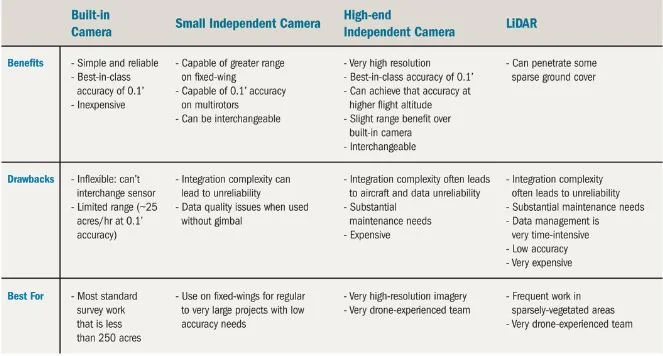
LiDAR Sensors
Several companies are starting to make drone-specific LiDAR sensors. These sensors produce point-cloud data, which require laser scanner software to manage and reduce into usable survey deliverables.
The primary benefit of LiDAR sensors over cameras is that they can penetrate some ground cover. On projects which have some sparse tree, bush, or grass cover, LiDAR can return some true ground elevations beneath the cover, reducing the amount of supplemental ground data collection needed.
The primary drawbacks of LiDAR come down to complexity and cost. LiDAR integrations are highly technical and complex, so very prone to faults, and requiring a great deal of time-consuming calibration and maintenance. LiDAR data management is also very complicated. Whereas drafting linework from photogrammetric orthophotos and 3D mesh surface models is somewhat straightforward, LiDAR requires working in point clouds. This requires very high-powered computers and a time-consuming process of selectively reducing point clouds down to only the points needed to create the surface. Despite this added complexity, LiDAR sensors are substantially less accurate than cameras – though LiDAR lasers are very precise, their ground-tested accuracy is usually around 0.3’. Finally, LiDAR is very expensive, making for a challenging business investment.
Our current analysis shows that LiDAR is still maturing. With its high cost to accuracy ratio, it is not a good investment for many survey firms today. However, for firms that frequently work on sites with moderate to sparse ground cover and have a great deal of experience with custom drone technology, LiDAR sensors, and point cloud management, these sensors could make a profitable option.