Who should process your UAV mapping data?
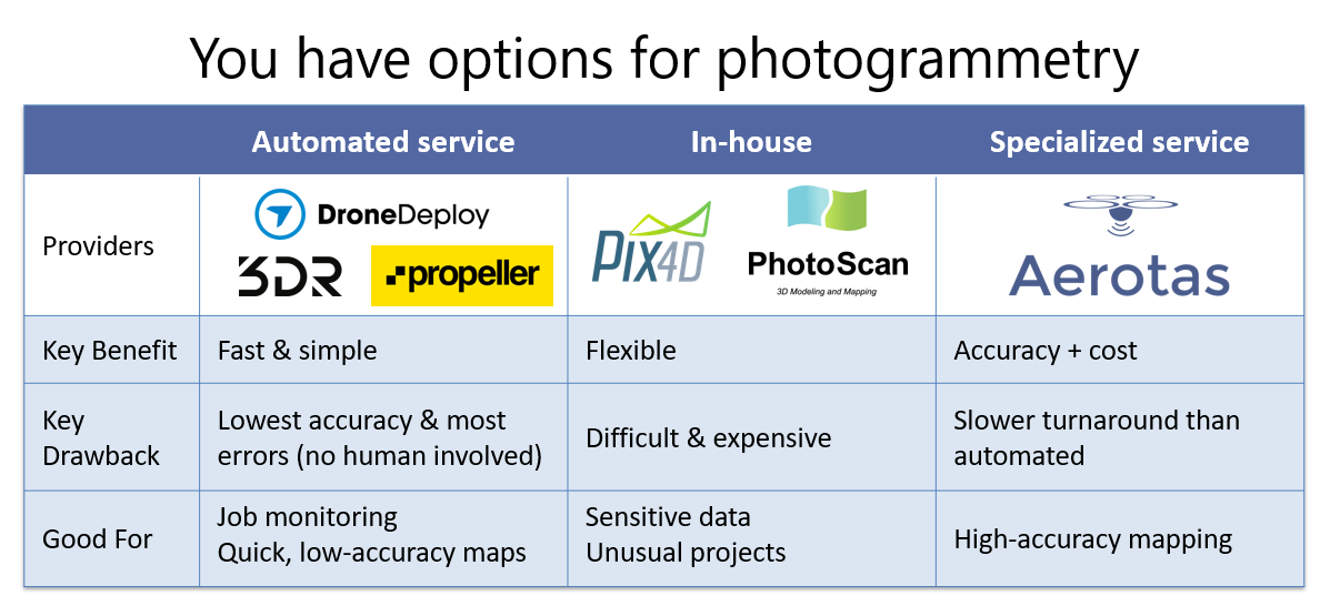
You have options for photogrammetry
By: Logan Campbell
As more land surveyors use drones as part of their daily work, they are finding themselves having to learn the ropes of photogrammetry. Having done data processing for thousands of drone survey projects for our customers, we have learned the hard way why photogrammetry is a Ph.D. level science. We have banged our heads against every wall that there is, and learned some essential lessons that we now apply to every project we do for our customers. We have explored which parts of the photogrammetry process can be automated and tested the fully-automated tools on the market. Ultimately we determined that having a qualified human involved in absolutely every project is essential to ensure we produce consistent, high-quality deliverables.
With the popularity of of UAVs in commercial applications increasing, more and more companies are regularly coming across the question of what is the best way to process drone data. There are lots of different options out there, and this article will describe the three major categories of how to process data, and the pros and cons of each one. Overall, there is no universal best answer. The best way to process data depends on the needs of each individual company.
THE RIGHT DRONE DATA PROCESSING DEPENDS ON YOUR BUSINESS
Cloud-based automated DRONE DATA processing
In automated processing, all that is needed is to upload photos to a web-server, which automatically processes them into standard outputs, such as digital surface models (DSMs), orthophotos, and point clouds. This type of processing is best known through one of the larger companies in the industry, DroneDeploy, though numerous other companies offer similar services, including Propeller, SkyCatch, and PrecisionHawk.
The biggest benefits to a fully automated solution are speed, simplicity, and cost. Automated solutions will typically offer the fastest turnaround time, simplest workflow, and lowest cost per project of all the types of drone data processing. If speed, simplicity, and cost are the most important factors,then automated processing is likely the best solution.
However, the biggest drawbacks to a fully automated solution are accuracy and customization. Because of their automated nature, these solutions are not able to achieve the same level accuracy as solutions that involve an expert touch, and they generally lack a manual QA/QC process to ensure quality data. Further, they cannot be easily modified to specific needs, as the outputs are fixed.
Overall, cloud based processing makes the most sense for companies that do not need particularly high accuracy. For things like safety monitoring, or just high-quality imagery, automated processing makes a lot of sense. However, if high accuracy and high reliability are the most important, it’s best to look at alternative processing options.
Local, self-processing OF DRONE MAPPING DATA
Those wanting to take full control of their drone data processing often look towards self-processing. In self-processing, each user would have to own their own computer and the software license to a photogrammetry suite, such as Pix4D, the market leader, or other softwares like Agisoft Photoscan, or Correlator3D.
The benefits of self-processing come from having control over the entire process. It can be run locally without an internet connection, which is great for remote locations. Also, the user has complete control over hundreds of tiny settings, allowing for a huge number of options to tailor a project to exacting specifications.
However, having control over the whole process means that the process takes a lot of time. A single minor mistake may take hours or even days of processing to correct, even after putting hours of manual work into a project. Further, self-processing can cost a lot of money. In addition to owning the software, high-quality computer hardware is also needed, typically costing around $3,000. Lastly, the learning curve on these software programs can be daunting. Getting a basic output can be done pretty easily, but getting high-accuracy, repeatable outputs can take years of learning and practice.
Because of these trade-offs, local processing usually only makes sense when cloud based processing is not an option for some reason. This may be because of remote locations, where good internet connections are unavailable, or because of highly sensitive data, that legally can’t be transmitted over the internet or processed by other companies. Outside of that, some form of outside processing is usually more beneficial.
Expert Processing FOR DRONE SURVEYING
Expert processing is when data is sent to an expert to process into the required outputs. This often appears similar to automated processing, since the basic upload steps are the same, however the difference lies on the back end. In expert processing, an expert will manually review and modify every data set to make sure that it is of the highest quality and reliably. Aerotas is the industry leader in expert data processing, however many other photogrammetrist firms employ expert data processing as well.
The key benefits to expert processing are accuracy and reliability. By having a professional with years of experience look at the data, unique and often dangerous errors, artifacts, and issues can be caught and fixed before ever making it to a client. Furthermore, if for whatever reason the data isn’t as accurate as needed, this can be flagged, rather than accidentally trusting inaccurate data, which can be very dangerous.
High accuracy doesn’t come without trade offs, though. Because expert processing isn’t a fully automated solution, it can take a day or two to process, which is slower than fully automated processing. Also, the human factor makes this usually more expensive than automated processing, but still cheaper than self-processing.
Wherever accuracy is a key requirement, expert processing is going to be the best solution. In industries such as Land Surveying and Civil Engineering, where compromising on accuracy and data reliability just isn’t an option, expert processing is the only responsible way to process data. However, if accuracy isn’t the highest concern, for roof inspections for example, then a different solution might be the best.
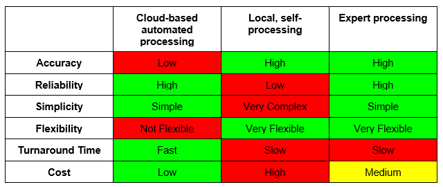
Pros and Cons of DRONE MAPPING Processing OPTIONS
what is the right DRONE DATA processing method for my company?
There are positives and negatives to every processing method. However, if you have a need for high accuracy, then expert data processing like that provided by Aerotas is the best choice. This is the best bet for high accuracy applications such as land surveying and civil engineering. If turnaround time and cost are more important, then automated solutions will work best. This would apply to projects like roof inspections or job site monitoring. Lastly, if for whatever reason you can’t use either of the above, then self-processing might be the right choice. This might be for sensitive government use, or very remote data processing.
Ultimately, the most important takeaway from this is to understand your needs, and pick a processing solution that works for you. One size doesn’t fit all, so make sure to choose correctly for your job!
Questions? Contact us anytime at (949) 335-4323, or info@aerotas.com


