
Drone Surveyors Can Now Fly Near Airports
Over the past year and a half, the FAA has continued to work to reduce limitations to commercial drone use, making drone operations more feasible in more situations. One big limitation that they have recently made headway on is flights near airports. Since the “Part 107” commercial drone law went into effect in August 2016, it has been possible to request authorization from the FAA to fly near airports, but the authorization process has been manual and quite slow -- requiring as much as a few months to clear. Fortunately, the FAA has now officially started rolling out a system that allows instantaneous authorizations, called LAANC.
How LAANC enables drone flights in classified airspace
LAANC (pronounced “lance”) is the FAA’s new system for allowing drones to fly legally in controlled airspace near airports. Like the prior, manual authorization process, LAANC grants commercial drone pilots access to restricted airspace. However, unlike the older system, LAANC is instantaneous. What started as a pilot test in Fall of 2017 has now begun to roll out nationwide, dramatically expanding the number of airports that participate in the LAANC process. This program is a huge boon for surveyors and engineers who might occasionally work near airports, however there are a few things to know about LAANC before going out and flying next to a runway.
While LAANC makes flying in controlled airspace faster and easier than ever before, there are still some restrictions. LAANC only allows access up to altitudes pre-approved by the FAA. Areas that are further away from airport centers will allow a pilot to get approval to fly higher (up to the general ceiling of 400’), while areas closer to the airport will have a lower ceiling (as low as 50’ in some cases). The center of the airports, or on the runways, will still require manual authorizations or waivers, which Aerotas can help you file. Check out the FAA Facility Maps to see what altitudes are allowed under LAANC.
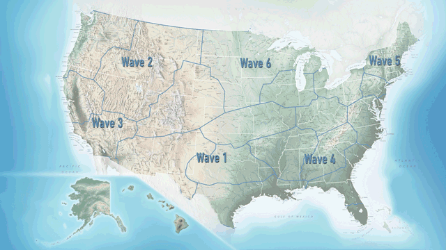
Can you get immediate airspace authorization at your local airport?
LAANC has not yet arrived at every airport, but is expanding quickly. The FAA has begun rolling out LAANC in waves, with the South Central wave already active. The dates for the rest of the country are:
May 24: Western North USA
June 21: Western South USA
July 19: Eastern South USA
August 16: Eastern North USA
September 13: Central North USA

The FAA is rolling out the LAANC program in 5 waves. Image courtesy FAA.
Within the regions that are released, not every airport will participate in LAANC immediately. About half of the airports will still require manual authorizations at the time the region first gets rolled out, with more and more airports are getting added every day. See the FAA’s website for the full list of LAANC approved airports.
Fortunately, manual authorizations are still an option, so just because a jobsite is in controlled airspace doesn’t mean it is a “no-fly” zone. Contact us to see how we can help streamline the authorization process for you

Part of the currently-active Wave 1 South Central area; LAANC-enabled facilities in green, manual authorization facilities in red. Image courtesy FAA.
LAANC means drone surveyors can easily do projects near airports
So how does it work? LAANC is quite easy to use. We recommend using Airmap to process your instant authorizations. All you need to do is create an account, enter your information (such as type of aircraft, where you are going to fly, etc.) and then hit submit, and you will receive instant authorization for your flight. You can learn more about Airmap at their website.

Instant drone airspace authorizationo. Image courtesy Airmap.
Once you submit an authorization request via LAANC, the FAA performs a few automatic checks to make sure it is safe to fly in the area. For example, it makes sure that the altitude you are requesting is clear of manned air traffic, and that there are no temporary flight restrictions in place. Then, it notifies the airport tower, and any manned aircraft in the area that a drone may be flying in the area you stated, and gives the tower your contact phone number in case they need to reach you for any reason.
LAANC is a fantastic step forward, helping to open up more airspace more quickly. What used to take 3 months, can now happen in minutes, with more coming soon. Do you have questions about how you can use LAANC, or need airspace authorizations filed for your survey projects before LAANC comes to you? Contact us or call (949) 335-4323