

Poorly Marked GCPs Introduce Error
The visual quality of an aerial target is crucial to maintaining accuracy throughout a drone survey project. It is critical to use ground control points (GCPs) with an obvious center point that can easily be picked out and marked by a photogrammetrist.

Ground control is crucial to ensuring the accuracy of your photogrammetry and, ultimately, your linework deliverables. Knowing how to shoot ground control points is essential; however, ground control distribution, quantity, and visual representation are all equally important. Each depends on the other to produce high-quality data.
GCP Best Practices
Five targets per battery (Non-RTK)
One target every time you move the base station, three per site (with RTK)
Corners of project + middle
One flight line beyond each side
Obvious center point
Visible from all angles
The tendency is to focus on the quantity and distribution of the ground control during mission planning - the layout. The quantity and distribution depend on the flight altitude and your expected accuracy. In general, surveyors are setting a minimum of five GCPs per project and using a layout that looks like the five side of a die, this is great! Read more about GCP Best Practices here. But, the aerial targets' visual quality is often overlooked.
The visual quality of a Ground Control Point is crucial to maintaining accuracy throughout the project. The targets should be visually contrasting and large enough to be seen at altitude with high precision. We find that pink and green tiles (colors not found in nature) tend to work the best and show the most precise center point, so there is no ambiguity in the target representation. Read more about the evolution of GCPs here.
Aerotas recommends a control point that has an obvious center point, like the target below. You can buy Aerotas Ground Control Points here.

Black and white vinyl kitchen tiles are also an effective alternative. Amazon sells a pack of twenty for about twenty dollars.

Along with visual representation comes stability. If your target is an object that can be moved, be sure it is appropriately anchored. If a ground control point gets kicked or blows away in the wind after you shoot it, it will be misrepresented as a moved or missing target.
Identifying the aerial target and marking the exact point that was shot is so important because the software does NOT do it for you with any precision. There is undoubtedly promise of a future where GCPs can be detected and marked automatically, but we are not there yet if the goal is survey-grade accuracy. When accuracy matters, there is a human-in-the-loop marking the GCPs, running a quality check, and correcting for errors.
Photogrammetry software detects the location of the ground control point. Still, it is ultimately the photogrammetrist who needs to make a judgment call on where the surveyor actually collected the point.
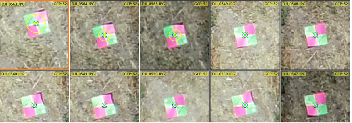
Keep in mind, the photogrammetrist has never been on-site and has not spoken to the surveyor who shot the control. The photogrammetrist has no context; they rely solely on what they see in the imagery. This is why it is so critical to use aerial targets with an obvious center point. Without an unmistakable center point, we are literally introducing error with each point that we mark. That is why our photogrammetrists love the checkerboard pattern. The center point of a tile like that is exact, and there is no guessing about where the center might be. This allows our photogrammetrists to pick out precisely the right point in the photo, without question.

More examples of poorly marked GCPs.
For example, from 200' AGL, the "dead center" of a bucket lid or a manhole cover is not crystal clear. It is open to interpretation, and interpretation can reduce the accuracy of the finished deliverable.
Chevron
The chevron is another popular target. However, different surveyors shoot different parts of the chevron, forcing a photogrammetrist to guess at the surveyor's intent, and this can introduce error that compounds throughout the model. Some surveyors shoot the inside corner of the chevron, some shoot the outside corner, and a small subset even shoot the center in between the inside and outer edge.

Shooting Range Target
Aerotas has received actual shooting range targets; one could assume that center mass should be marked. But again, the lack of a clear and unambiguous center point can introduce error, and a tenth here and a tenth there adds up quick when you are trying to ensure full-site accuracy.

Spike of a Guy Wire
Visual ID points like a manhole cover, the base of a signpost, the end of a parking stripe, the spike of the guy wire, or the corner of the concrete have their place in drone surveying. In fact, visual ID points like these could save a project if there were a lack of GCPs in a particular area or if a GCP was moved during flight.

Base of a Signpost
The base of a signpost can help save a survey's accuracy if it is the only visual ID point available. But, a signpost has a significant drawback: the photogrammetrist does not know if the surveyor shot the front, back, or side of the post, and mismarking it can introduce error.
These permanent structures were captured in the imagery. If you can revisit and shoot a few of these structures, then the photogrammetry can be tied down and verified accurate without re-flying the entire site with new control. But, visual ID points are inferior to good quality aerial targets with a checkerboard pattern and colors that do not exist in nature.
Possible Visual ID Points
Manhole Cover
Base of a signpost
End of a parking stripe
Spike of a guy wire
Corner of the concrete
Aerotas strongly recommends actual GCPs with a checkerboard pattern when setting up your mission. You will see better, more accurate results. Only use visual ID points as a last resort to prevent re-flying the entire site.

If you would like to discuss ways to improve your drone program Aerotas is here to help.
INCREASED FLEXIBILITY | SAVE TIME | BETTER DELIVERABLES
Contact us anytime at (949) 335-4323, or support@aerotas.com