How drones are helping rebuild after the California wildfires

How drones are helping rebuild after the California wildfires

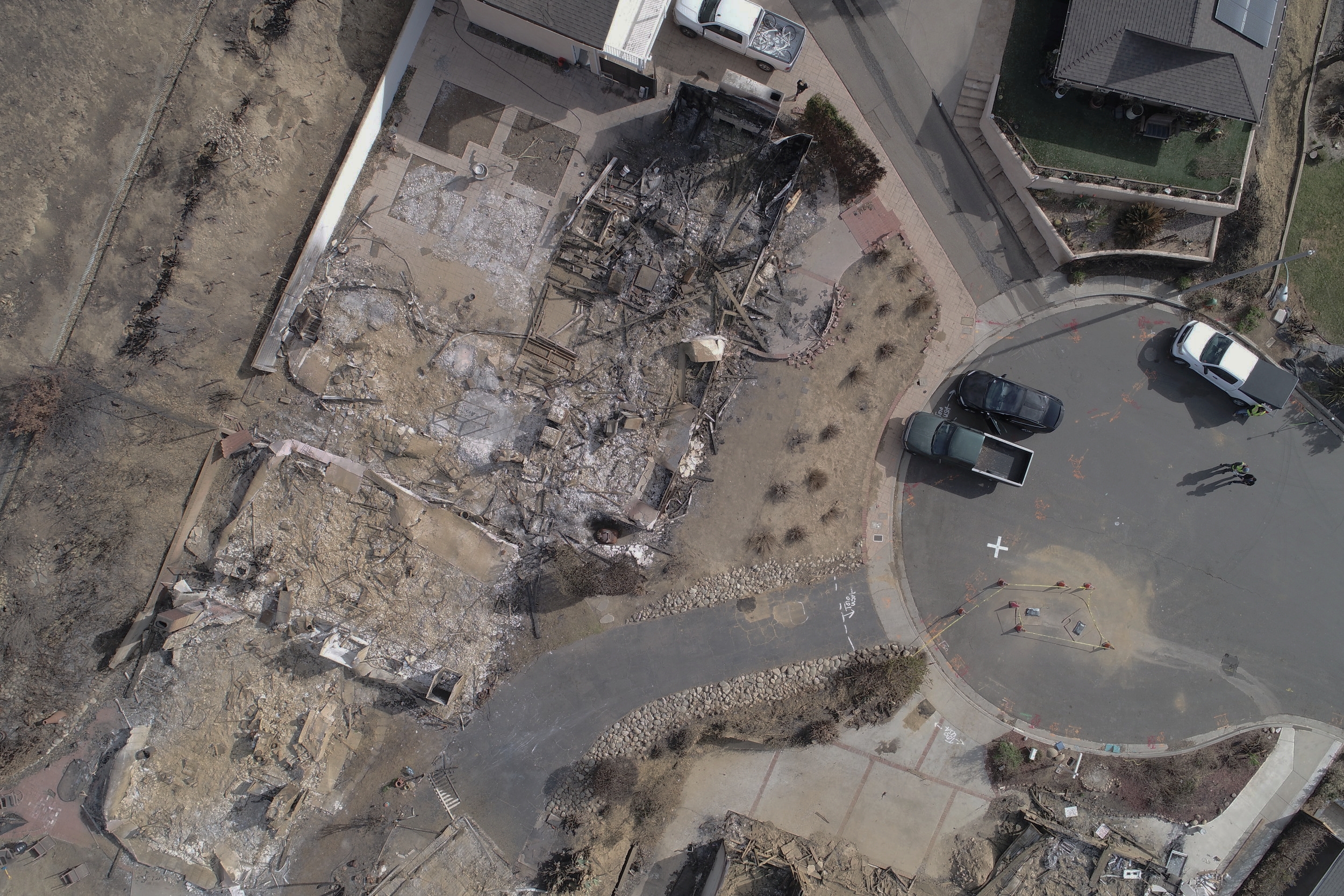
The recent California wildfires destroyed thousands of homes, leaving many people struggling to get back on their feet. Rebuilding after such devastation can take years, adding heartache and financial strain on already troubled families. Thankfully, drone technology is making this process smoother. A good drone program can make much of the rebuilding process easier on homeowners, land surveyors, and many other parties involved in getting life back to normal. WM Surveys in Ventura, working with the Aerotas Mapping System, is helping to do exactly that.

Which Drone Processing Solution Fits Your Business?

Which Drone Processing Solution Fits Your Business?

In an interview with Commercial UAV News, Aerotas founder Logan Campbell helps readers determine which of the many options for processing drone data is best for them. There are so many options for turning photos from a drone into some sort of final product that it can be quite confusing for many businesses. One of the most important factors is understanding the trade offs of purchasing the data processing software themselves, versus having an expert provider like Aerotas do the work for them

Drone Surveying Webinar for NYSAPLS

Drone Surveying Webinar for NYSAPLS

On December 1, 2017, Aerotas co-founder Daniel Katz presented a webinar for the New York State Association of Professional Land Surveyors. In the webinar, Daniel covers key lessons Aerotas has learned from training over 200 land surveyors on high-accuracy and profitable drone mapping.

POB Column: Grow Your Surveying Business Without Hiring

POB Column: Grow Your Surveying Business Without Hiring

In the December issue of Point of Beginning, Aerotas co-founders Logan Campbell and Daniel Katz explore a key issue faced by the land survey community: how to keep up with rapidly growing demand despite a shrinking workforce.

Now is the time for a drone investment

Now is the time for a drone investment

The hype is finally dying down in the world of drones. Thank goodness. Throughout 2015 and 2016, many people dreamed and opined about how drones could bring us new shoes in 20 minutes. However we at Aerotas, and our clients, have been focusing on how to actually make drones work in the real world. And now there are 60,000 commercial pilots in the US doing real work with drones – and many of them are surveyors.

Who should process your UAV mapping data?

Who should process your UAV mapping data?

With the popularity of of UAVs in commercial applications increasing, more and more companies are regularly coming across the question of what is the best way to process drone data. There are lots of different options out there, and this article will describe the three major categories of how to process data, and the pros and cons of each one. Overall, there is no universal best answer. The best way to process data depends on the needs of each individual company.

Maintaining healthy skepticism of new drone ideas

Maintaining healthy skepticism of new drone ideas

As experts on the drone industry, we often receive requests to weigh in on new ideas in the industry. While a healthy climate of innovation still exists in the drone industry, not all new ideas are good ones. As our clients prove every day, drones have become essential basic tools for many businesses, but that does not mean that all drone-related concepts are so valuable. We were recently asked by the blockchain technology experts at Smith + Crown to review a unique new proposition they had come across, which proved to be an excellent example of hype overshadowing real-world value.

Who owns the air above your home?

Who owns the air above your home?

Who controls the airspace above your home? This question is beginning to generate a lot of attention lately. Under the current law, there is no clearly defined line to understand the answer. The courts have been kicking this concept around for decades and until recently have had relatively little need for clarity. Considering the increasing use of drones from both commercial and recreational users flying in this space, there is growing pressure to resolve this lack of clarity.  The “grey area” has yet to be defined.

How a drone survey accidentally saved us $600

Anyone that has worked in large public areas before knows that there is always a risk of theft, vandalism, or loss of equipment. It is simply an unfortunate part of the job, as it often costs more to protect the equipment than to simply replace it. This was the situation I was in at the end of a drone survey earlier this week, and it put me in a pretty awful mood. After our flights were completed, I walked the site to pick up our ground equipment only to discover that one of our $600 GPS-enabled aerial targets had vanished without a trace.